In automation and process control, the main rule is that one must understand a process before one can control it. My goal in this column is to describe the polar vortex process in terms of its formation, behavior and its response to warming. (I might add that the same could be done about flooding by just considering that the oceans were the warmest on record in 2018, that warm air holds more moisture and that it returns by precipitation).
Because gravity fixes the atmosphere to the Earth, it should rotate with the Earth and there shouldn't be any air circulation, unless some force upsets the atmosphere's equilibrium. The source of this force is the sun, which fuels winds by creating temperature differences that, in turn, cause pressure differences that make air move from high- to low-pressure areas. Wind speed and direction are determined by the pressure gradients that exist between high- and low-pressure areas. In the Northern Hemisphere, (because of the Coriolis force caused by the rotation of the Earth), winds circulate in a clockwise manner around areas of high pressure and in a counterclockwise manner around regions of lower pressure.
Over hot spots, warm and humid air rises and sucks in dryer and colder (therefore heavier) air at the bottom, while the Coriolis force (in the Northern Hemisphere) rotates this evolving cyclon counterclockwise over the hot spot. Over cold spots, the opposite occurs. There, the cold and dry air, instead of rising, sinks down, thereby creating a high-pressure zone and a clockwise circulation.
At the poles, in the upper regions of the stratosphere1 (the stratosphere at the poles starts at about 7 km (23,000 ft, 4.3 miles) and reaches as high as around 30 miles or 50 km), the amount of solar energy received is low (and in the winter, none at all). The low angle of the arriving solar radiation causes very low temperatures and, therefore, dense air and relatively high pressure.
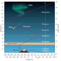
Figure 1: As altitude rises, up to about 10 km in the troposphere, atmospheric temperature keeps dropping to a low of about -60 °C. When altitude reaches the ozone layer, this reverses, and temperature starts rising again and reaches 0 °C by the upper border of the stratosphere at about 50 km.
In the stratosphere, the temperature rises with altitude. Below the stratosphere, in the higher regions of the troposphere, the temperature drops with rising altitude. This reversal is caused by the ozone layer, which absorbs the ultraviolet light of the sun (Figure 1) and prevents it from entering and heating the troposphere. An increase in temperature contributes to the lowering of the pressure in the stratosphere and, therefore, the vortex force swirls the air counterclockwise and inward toward the pole. This helps to keep this cold and swirling body of air near the poles, and this phenomenon, we call the "polar vortex."
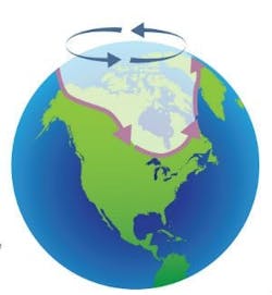
Below the stratospheric polar vortex, which forms only in the winter, is another vortex in the troposphere (up at around around 5 miles or 8 km) that operates year-round. It's larger in diameter and its boundary winds are more commonly called the "polar jet stream." This second vortex is usually referred to as the "polar vortex." The large difference in temperature between the air of the polar vortex and air further to the south, in the mid-latitudes, drives the polar jet stream. The interface between the cold, dry air mass nearer the pole and the warm, moist air farther to the south defines the location of the polar front. The polar front is centered at roughly at 60° N latitude (Figure 2) and the wind it creates is usually called the polar jet, which also rotates counter-clockwise (west to east).

Figure 2: Illustration of the stratospheric (blue) and tropospheric (violet) polar vortices. Rotation of both is counterclockwise (west to east). When global warming weakens the polar jet stream (violet), that results in breaking it up and the formation of meanders that dip down to the south.
A polar vortex strengthens in the winter and weakens in the summer because its strength depends on the temperature difference between the mid-latitudes and the poles. When the vortex is strong, it’s a clearly defined single vortex, and the Arctic air is well contained within the vortex because of the rotation's high velocity. Under such conditions, the diameter of the path of the polar jet stream is stable. This path of the polar jet forms a boundary between the very cold Arctic air and the warmer air over the mid-latitudes. In the winter, this path is near the border between the United States and Canada.
Global warming destabilizes and upsets this weather pattern. This is because the Arctic is warming twice as fast as the rest of the planet. This warming is due to the melting of the highly reflective ice in the Arctic Ocean because as the highly reflective ice surface is replaced by water, it absorbs much more solar heat. This is the reason for the fast temperature rise, which is called the "albedo effect2.”
The consequence of this warming is the development of the relatively warm spots on the ocean's surface, which warms the air in those areas. This makes the temperature difference between the arctic and the mid-latitude air temperatures less distinct, which causes the polar jet stream to weaken. When weaker, it can break into two or more vortices, and when very weak, the flow of Arctic air becomes even more disorganized. At that time, it sends cold Arctic air to the south, bringing with it a rapid and sharp temperature drop. Under such conditions, the polar jet stream meanders instead of making a beeline around the planet. The meandering causes the cold air of the polar vortex to wobble, and slipping of cold air to the south from the Arctic to over the United States, Europe or Asia.
In this way, the rising of the warmer air, caused by the hot spot's albedo effect, tends to break up the single and stable polar vortex, and generate fluctuations, reversals and "daughter vortexes" (also called kinks or wobbles). These extremely cold daughter vortexes can bring extremely cold air to parts of the United States that are normally well south of the jet stream.
Footnotes
- The stratosphere is stratified in temperature, with warmer layers higher and cooler layers closer to the Earth. This temperature increase with altitude caused by the ozone layer absorbing the sun's ultraviolet radiation. This is in contrast to the troposphere, nearer the Earth's surface, where temperature decreases with altitude. The border between the troposphere and stratosphere (the tropopause) marks the line where this temperature inversion begins. Near the equator, the stratosphere starts at as high as 20 km (66,000 ft, 12 miles); by the mid-latitudes it drops to around 10 km (33,000 ft, 6.2 miles); and at the poles to about 7 km (23,000 ft, 4.3 miles).
- The albedo effect (reflectiveness) for white snow is 70%, while for water it's just 7%.

About the Author
Béla Lipták
Columnist and Control Consultant
Béla Lipták is an automation and safety consultant and editor of the Instrument and Automation Engineers’ Handbook (IAEH).
