It used to be only big-ticket, high-value applications and deep-pocketed, heavy-industry end-users could afford constant process monitoring, visualization and control. Well, times changed, prices went down, processing power increased, and now pretty much everyone can afford to gather data with Ethernet and wireless networking, analyze data with sophisticated software, and display it on ubiquitous interfaces including tablet PCs and smartphones. However, the trick is still to apply these less-costly technologies in applications and enable more effective decisions.
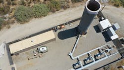
For instance, the 2 million residents of San Bernardino County, Calif., have generated plenty of garbage throughout the years, and just like everyone else, they also needed to find a place to put it. Encompassing greater Los Angeles, the county covers 20,105 square miles and is the largest by area in the United States—close to the size of West Virginia. All this real estate gave the county abundant options for storing its trash, and it built and presently operates about 28 landfills, including its almost 500-acre San Timoteo facility (Figure 1).
However, San Bernardino County's landfill gas (LFG) monitoring and control systems aged during the years, and its equipment grew increasingly cumbersome and difficult to use. While many U.S. landfills still manually record data such as gas levels and device runtime hours, the county had been using PLCs and touchscreen HMIs running third-party software on a virtual private network (VPN). This setup managed four blowers connected to the flare station at Sam Timoteo, and visualized temperature information from its thermocouples, as well as pressure, level and current data from related devices.
"This system was secure, but it was difficult to access," says David Hostetter, regional manager of the eight-year-old remote monitoring and control (RMC) group at SCS Engineers, a multi-disciplinary engineering, environmental consultant and contractor in Long Beach, Calif.
Simpler, streamlined SCADA
To develop and upgrade to a simpler, more capable and closely connected, and less costly LFG monitoring and control solution, San Bernardino County recently sought help from SCS, and they designed and implemented the pilot project at San Timoteo with 340 tags, 16 screens and more than 50 alarms. The landfill typically logs almost 9.7 million rows of data from 261 tags to a database. The SCS RMC pilot employed a flexible, scalable platform for desktop or mobile data access, which consists of Ignition 8.0 web-based SCADA software, Ignition Perspective software module, and an Ignition Edge gateway from Inductive.
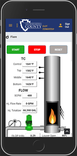
These software and hardware components enabled San Timoteo to migrate from its less-flexible VPN to a web browser-based SCADA system with interfaces rendered in HTML 5, so they can be viewed on any-sized screen (Figure 2). Ignition Perspective not only allowed SCS to display the typical components of a regular system, it also let them embed Pix4D maps inside the web-based interfaces.
Figure 2: The SCS RMC pilot project at the San Timoteo landfill employs a flexible, scalable platform for desktop or mobile data access, which consists of web browser-based Ignition SCADA software with interfaces rendered in HTML 5, so processes and equipment such as its flare station can be viewed on any-sized screen from laptop and tablet PCs to smart phones. Source: SCS Engineers and San Bernardino County
"In addition to displaying data and status indications, Ignition software also lets the landfill's operators remotely change variables, turn its flare on and off, adjust blowers and valves, and reset alarms," says Hostetter. "We still use the VPN, but now the devices are easier to access."
In fact, because Ignition 8.0 was still in beta testing when it was installed in the pilot at San Timoteo, SCS was able to add new features during nightly builds as they approached the project's deadline. These included integrating trends and graphing functions to meet San Bernardino County's requirements and deliverables. The county also specified that the upgrade let it easily access online data without using Java, which the Ignition 8.0 Perspective module could do. Finally, the gateway established an onsite hub-and-spoke topology, and connected the site to SCS RMC’s cloud-based Ignition system to enable a complete enterprise solution.
"Overall, this improved SCADA system gives San Timoteo's operators and San Bernardino County's managers much clearer views of their landfill operations, and a better understanding of their processes and equipment status, which greduces operations and maintenance costs," says Hostetter. "In addition to remote monitoring and control, San Timoteo has gained automatic reporting functions that make it easier to understand what's going on along with the new SCADA system's remote visualization and alarms.”
Wireless and wild blue yonder
Beyond implementing its new SCADA capabilities, San Timoteo's upgrade and pilot project also involved adding some wireless components which link to remote sensors and devices.
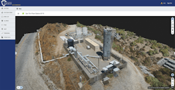
Figure 3: The San Timoteo landfill's updated SCADA system is further enabled by 3D imaging from flying drone units, which collect graphical data, compose topographic mapping, make 2D images and 3D renderings, and generate GIS, thermal and tunable diode laser (TDL) data for methane leak detection. The images can also be applied to a Microsoft HoloLens AR headset, which lets San Bernardino County's operators and managers use any authorized mobile device to remotely "walk the site" from anywhere. Source: SCS Engineers and San Bernardino County
"San Timoteo has wireless built in to gather data from multiple sources," explains Hostetter. "We use it to see full-site operations by pulling information from our pumps, flares and blowers, deliver it to our SCADA system, and use a panel PC to enable the interface, show its status, and allow more accurate control functions. Ignition 8.0 can run on this PC or on cloud-computing services that can provide better payback than traditional methods used to give us."
Moving beyond fixed-device wireless, SCS Engineers also used the pilot project at San Timoteo to integrate added options such as 3D imaging from flying drones and augmented reality (AR) displays. After flying over the site, collected imagery is uploaded to update its map and create point-cloud graphics. SCS uses aerial data to compose topographic mapping, 2D images, 3D renderings, and GIS, thermal and tunable diode laser (TDL) images for methane leak detection. SCS also embed 2D images and 3D rendering into Ignition Perspective, so other users can take advantage of it (Figure 3).
Finally, the team took its rendered images and applies them to a Microsoft HoloLens AR headset, which lets San Bernardino County's operators and managers remotely view the site using any authorized mobile device, and “walk the site” from their offices or anywhere using the HoloLens. Plus, the county's IT staffers are happy they don’t have to worry about Java on their system.
Hostetter reports that six other Ignition 8.0 Perspective-based and 10 Ignition Vision module-based SCS RMC systems are presently running at landfills nationwide. Hostetter adds that several more are planned.


